 Researching mapping: methods, modes and moments in the (im)mutability of OpenStreetMap
Abstract
This paper explores the potential of the OpenStreetMap (OSM) and investigates the discourses and performances enacted by participants in the light of a research agenda focusing on “modes, methods and moments of mapping” revealed in the project (Dodge, Perkins & Kitchin, 2009). The approach taken in this paper was to select key elements from the manifesto and critically consider these in light of OSM. In so doing, there are of course overlaps between themes, but the manifesto offers a focused means of redefining emergent approaches to mapping. Collaborative approaches such as OSM, which are based upon volunteered input into shared internet-based resources, seem to offer a radical alternative to more traditional mapping, subverting proprietary systems by apparently changing politics. However the research presented here argues that we need to attend more to the mutability of "‘crowd-sourced" neo-geography, but instead of assuming a profound political change occasioned by a technological shift this paper suggests contextual studies encompassing local practice need to be researched. We need to be aware of the diverse sites at which meaning is constructed and to recognise tensions in new social engagements and the meanings called into being by crowd-sourced mapping practices, but also to acknowledge the immutable elements that remain in an apparently constantly emergent mapping process.
Introduction
In 2009 in the concluding chapter to our book Rethinking Maps (Dodge, Perkins & Kitchin, 2009), we put forward a manifesto for map studies, that focused on modes, methods, and moments of mapping. We argued that researchers might usefully focus on interfaces, algorithms, authorship and infrastructures associated with different modes of mapping. We suggested that it might be profitable to examine mapping through the methodological lenses of materiality, money, affect, and ethnography. We also suggested research might profitably question when and where mapping really matters by investigating places and times of failures, points of change, the time-space rhythms of map performance, memories of mapping, academic praxis and newly creative engagement with mapping practice.
This manifesto is situated at a particular moment in a changing intellectual, social and technological terrain (see Kitchin, Dodge & Perkins, 2009). Orthodox accounts of the significance of mapping tell a story of progressive improvements in representational accuracy. Scientific ways of knowing are privileged in these accounts, which have continued to accommodate and encourage shifts in technology. Indeed mapping as an intellectual pursuit continues to be dominated by scientific ideas predicated on assumptions of neutrality, with a focus on how maps work, (see for example MacEachren, 2005) and on methods of geo-visualisation.
In the 1980s, increasing concern with the marginalisation of mapping studies from the social scientific mainstream encouraged scholars to adopt social constructivist understandings of mapping and its disciplinary practices. Maps were read as bearers of power knowledge, a form of elite discourse, wrapped up with the exercise of power in different social contexts (Harley, 1989; Wood, 1992). The image had became corporate, anonymous and a view from nowhere (de Certeau, 1984). Maps offered the modernist project a means of governing the territories that they purported to know (Wood, 2009) and so mapping had picked up an authoritative and apparently mimetic power to represent the world.
Subsequent studies of mapping as a social force drew upon diverse theoretical positions to make increasingly critical comments about the institutions, contexts, products, processes and practices involved in mapping (see Crampton & Krygier, 2005 for a useful overview of these emerging themes of critical cartography). For example Edney (1993) attacked progressivist ways of knowing and called for a more contextual and relativist understanding of the form; Wood (2008) deployed Barthean semiotics and focused on maps as a cultural spatial propositions; Crampton (2003) used Foucauldian notions of bio-power and power knowledge to explore the role of the map in regimes of governance; and Pickles (2004) explored the power of maps as over-coded inscriptions contributing to the history of spaces. Others drew upon science and technology studies to focus on the actors and networks through which mapping circulated. Latour (1990) argued that maps work as immutable mobiles, comprising sets of inscriptions carrying meanings into new contexts and facilitating scientific practices and governance. He suggested that the power of the map resided in the agency of transcriptions to circulate and reify practice. Immutable mobiles did their work by being flat, and were capable of being folded, rescaled, recombined and super-imposed with other media. The links and practices facilitated by mapping were the mechanism by which power was transferred.
More recent critical mapping research has shifted towards more cultural and local understandings (Perkins, 2008). The emphasis has moved towards more relational approaches encompassing social and cultural diversity and investigations of particular mapping contexts. Inspired by feminist researchers and post-constructivist thought, scholars began to reject dualistic notions and to focus on how maps might work as hybrid co-producers of spaces (Del Casino & Hanna, 2005). This cultural turn also encompassed a move away from product and towards mapping performance. Researchers such as Brown and Laurier (2005) suggested that we might usefully attend to the ethno-methodology of mapping in particular social tasks. Informed by Deleuzian notions of flow, recent work has focused on the emergent possibilities the medium calls into being. Corner had stressed as long ago as 1999 the emancipatory and creative possibilities of the mapping, and Dodge and Kitchin (2007) argue we need a shift in perspective, from seeking to understand the ontic status of maps, to examining their ontogenic potential. They argue mapping is best regarded as a set of unfolding practices, an emergent assemblage of ways of calling possible futures into being, in the context of particular practical tasks.
Technological change is clearly an important contributor to these different ways of approaching mapping and over the last half a century the domain of the printed paper map has gradually declined in the face of a radical reshaping of data collection, manipulation and display technologies. The latest innovations have seen the emergence of social networking and locative technologies that call new forms of mapping into being, offering a democratized potential in new spaces, and displacing the old representational certainty of a fixed map as being somehow separate from and subsequent to the world.
‘Crowdsourcing’ has emerged from the appearance of Google Maps in 2005 as a new way of ‘doing’ mapping. Commentators have suggested that these new forms offer a radical reworking of the medium and might usefully be termed neogeography (Turner, 2006), volunteered geographic information (Goodchild, 2007), or 'wikimapping' (Sui, 2008). They depend upon Web 2.0 technologies (O'Reilly, 2005) involving a decentralized collecting of information by volunteers, RSS feeds for instant communication, mash ups combining and overlaying datasets, and blogs. Users can access Application Programming Interface code to share and merge spatial data. Older notions of elite knowledge are being supplanted by the bottom up alternative of the wisdom of the crowd (Tapscott & Williams, 2005) and it has been suggested these changes are part of a profound catalyst for democratic change (see for example Beer & Burrows, 2005). Bruns (2008) focuses on the key implications of these changes, which he terms'produsage' of information. He suggests Web 2.0 initiatives involve: a shared engagement by a community beyond an elite group; fluid roles for participants; an unfinished, frequently overwritten, palimpsestic content; and a frequently liberal attitude to intellectual property rights. Many of these initiatives are also informed by cyber-libertarian ideas, that grew from the open-source software movement, and are characterised by an opposition to proprietary closed information. Other researchers have considered the economic implications of the shift to 'prosumption', seeing the process as a new form of capitalism, in which consumers are enrolled into generating new content, without participating in a wage relation (Ritzer & Jurgenson, 2010). The implications of this process have of course been critiqued, with suggestions that the ignorance of crowds might encourage a decline in specialist quality (Carr, 2005), and that the whole process needs to be historicised as a capitalist response to the post-dotcom boom of the 1990s, and a boosterist attempt to create new value, without the old requirement to pay for labour (Silver, 2008).
Arguably the most successful and quintessential crowd-sourced mapping project to emerge in this period has been OpenStreetMap (see Ramm & Topf, 2010 and http://www.openstreetmap.org). Commentators have suggested that it is perhaps the most significant open source project to date (Lin, 2011) and is already having a significant impact on cartography (Chilton, 2011). This paper focuses upon the project, reading its (im)mutability against the mapping manifesto that we proposed, and exploring its social production, contested significance and trajectory.
OpenStreetMap (OSM)
OpenStreetMap.org was registered as a URL in August 2004 by Steve Coast. The idea was to develop a ‘wikimap’ with an open architecture, constructed in a collaborative process, to challenge the hegemony of national mapping agencies. A map for the community by the community, free in the sense that it is open, with minimal restrictions on re-use. OSM placed no limits on reuse, unlike proprietary mapping produced by national mapping agencies, or ‘free’ mapping (without charge) from online mapping portals.
Registered users of OSM can upload GPS tracks and points of interest, convert these to ways, add relations and tag them with names or a thematic classification. The users decide how to map and write the code. They decide on directions the project should take and document everything about the process in the project wiki. The system displays these data online to anyone and also makes datasets available to any registered users – registration is free and the only conditions on use are to comply with the open licence 1. By August 2011 there were 444,611 registered users, and the database contained 2,463,189,057 uploaded GPS points, 1,166,607,268 nodes, 103,584,037 ways and 1,067,288 relations. Growth continues to be exponential across almost every criterion. Applications have been developed for diverse platforms, and spin-off commercial companies floated. Major players in the new global geo-economy have come to recognise the significance of these data.
But whilst mutability and dynamism characterise many aspects of the data displays in OSM it has been argued that other aspects of the project continue to offer fixed meanings that reflect Latourian ideas of immutability (see Perkins, forthcoming). Latour himself suggested in an interview in 1997 that the digital transition had done little to change the status of the map as an immutable mobile. He argued it merely speeded up circulation and recombination and privileged new connectivities: both are self evident in OSM. Lammes (2011), whist acknowledging the mutability of interactivity, also suggests that digital mapping systems continue to fix meanings: hidden algorithms and mapping interfaces serve as sites in which immutable notions are inscribed. The displays may be interactive, ephemeral and fleeting, but the authoritative rhetoric of the map remains.
So it seems reasonable to acknowledge elements of fixity and change in OSM, and to focus upon the contested negotiations, discourses, actions, actors, technologies, organizations, aesthetics and contexts that together bring the mapping into being 2. In this view, mutability is contingent and played out in tensions across different sites, which makes OSM particularly amenable to a multifaceted research agenda focusing on modes, methods and moments.
Modes, methods and moments in OpenStreetMap
Interfaces and algorithms
More and more everyday mapping is encountered as part of a digital interface. What are the cultural, social and economic relations that bring the interface into being? Map studies need to open the ‘black-boxes’ of mapping software, to start to interrogate algorithms and databases, and in particular to investigate the production of ready-made maps that appear almost magically on the interfaces of gadgets and devices we carry and use everyday without much overt thought (Dodge, Perkins & Kitchin, 2009: 221-2).
OpenStreetMap is unusually transparent. The project code is open and available to all and changes in interface design are carefully documented and debated on the project wiki. In theory interfaces and algorithms are open to change by anyone in the community, in practice both reflect the input of only a very few key individuals, probably no more than 50 in number, who have the power and skill to write project code and control interface design (Eckert, 2010). The overwhelming majority of nearly half a million registered users have only limited influence on project trajectories. The interface actively influences mapping behaviour: its agency significantly impacts on what can be done with the map.
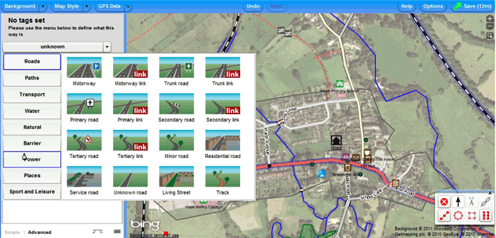
For example research suggests that editing software made available through the interface strongly influences participation (Weber & Jones, 2011). The release of Potlach 2 in 2010 – a supposedly more user friendly online Flash-based editor – may offer easier access to map making and encourage editing, with its facility for displaying image backdrops that may be traced . Improving system response times has also widened access for people contributing to OSM or using the interface to look at the map. However there remain significant technical barriers to wide participation.
The OSM interface is not a fixed entity and is frequently updated by those with the power and skill set to develop the project API..
In the early days of the project the interface was not very user-friendly and mappers could not even easily display the data that they had uploaded and edited.Despite frequent upgrades the interface has always encouraged a strongly instrumental take on mapping, implicitly encouraging users to take on board the ethics of the project. 3 It attracts those with the technical ability, persistence and motivation to buy into these tropes. And applications of the project have mostly also been instrumental, responding to the immutable ideas embedded in the code
Visual culture
We would argue that a new and critical engagement with visual studies could usefully inform research into mapping.... technology alone is insufficient an explanation for the role that new kinds of mapping are playing in society (Dodge, Perkins & Kitchin, 2009: 223).
It can be argued that the visual displays deployed in OSM are demonstrably mutable. Like all maps OSM evolves as edits accumulate, but unlike most maps the visuals of the project draw attention to this processual and ontogenetic nature (Kitchin & Dodge, 2007). In many of its sites, fixity is denied. On the front end to the web site an edit tab beckons and a history tab allows earlier changesets to be displayed. The slippy map is under the control of the user who can pan and zoom or change the look of the display. There are also mutable default displays from different rendering engines that may be turned on or off: users can decide whether to view Mapnik, Osmarender, OpenCyclemap, or the No Name base layer, or to highlight data on top of these to reveal histories of particular features. External sites facilitate rapid and complete change of all specifications and user control over the look of every feature of the map (see http://maps.cloudmade.com/editor).
Many other projects feed off the OSM data, offering mashups targeted to particular uses: OpenCycleMap, OpenOrienteeringMap, OpenPisteMap, and open maps for WheelChair and Blind Users amongst others offer different visualisations. The possibilities seem to be only limited by the emergence of a sufficient community to develop a web site, write the code and visualise a new theme. However the design of the OSM maps mostly evokes conventional web cartographic displays – its interactive mutability deploys few significantly new visual devices, and the look of the maps connotes an often conservative aesthetic, evoking the form of yet another slippy map controlled road map. The visual culture of the form is limited by the agency of authorship.
Authorship
How do new models of map authorship work in practice, for example: how are power structures altered by the rise of the amateur mapper; how do crowds can generate wisdom in cartography; to what extent is the democratisation of production really taking place; how might map ‘hackers’ fashion genuinely useful hybrid forms of cartography ... who are the new collaborative authors and why are they motivated to map; and what kinds of mapping do they do and is that mapping of quality and utility to others?(Dodge, Perkins & Kitchin, 2009: 225).
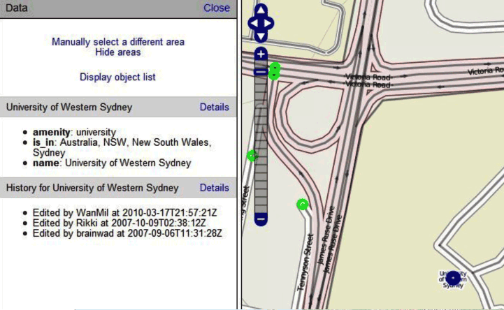
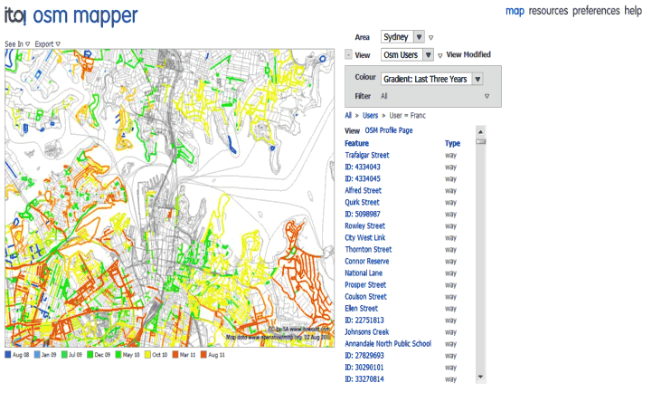
Authorship in OSM is at once individual and shared – hidden but also celebrated. The map appears to be anonymous, no authors appear prominently at the top level of the site and names of participants are hidden in the assumed online IDs. Like all modernist maps, its authority in part derives from this denial of subjectivity (Wood, 2009). However these subjectivities can be uncovered very easily in the project. On the site itself truly anonymous submission is not possible – every track can be traced to an individual ID: by selecting the data layer and highlighting an object its history and authorship can be displayed [Figure 3]. The wiki strongly encourages OSM users to contact other users, to participate in the mapping community. External tools identify responsibility for the changing map, such as ITO World OSM Mapper which highlights parts of the map created by different users. Authorship is also celebrated in the real world of mapping. Local social participation in Mapping Parties emphasizes real world interaction.
The authors of OpenStreetMap are mostly well-educated and younger white men, often employed in education and technology-related jobs. Hakklay and Budhathoki (2010) report 96 % of their sample of OSM mappers as men, 78% as having a university education, and 86% as between 20 and 50 years old. Class divides in existing mapping are replicated in OSM: Hakklay (2010) shows that middle class areas are better mapped than poorer areas in the UK, and on a global basis it is in Western Europe that OSM offers best coverage. And the project is far from amateur or egalitarian: clear bureaucratized hierarchies have emerged, with expertise strongly concentrated in a minority of participants, whilst the majority at best just collect a few tracks and then drift out of the project (Perkins, forthcoming). Those who do map and who tag ways and points of interest can deploy whatever tags they feel are appropriate. However authorial freedom requires procedural rules for establishing new tags, and for resolving disputes. Disputes and occasional edit wars do take place. Tensions surface over geopolitically contentious areas, for example over the form of names to be used in Northern Cyprus in 2007.
Infrastructures
Researching mapping as an infrastructure needs to foreground the materiality of production, render transparent usage, and de-naturalise the everyday appearance of maps by highlighting corporate structures that underlying mapping. Secondly, it is important to analyse the ways in which mapping modes contribute to infrastructures themselves (Dodge, Perkins & Kitchin, 2009: 227-8).
The open and free rhetoric of OpenStreetMap emerges from an infrastructure that is deliberately decentralized. The community operates ostensibly as a ‘do-ocracy’ – in which individuals who can contribute what they want to, instead of delivering work on the basis of a prescribed role or elected position. As the project has developed so has the infrastructure, along with necessary regulation and bureaucracy. The OpenStreetMap Foundation, its elected board and seven working parties, advises and partly regulates development of the project. The amount of work for unpaid Board and Working Group members of the OSM Foundation has significantly increased over time, and includes moderating mailing lists, adjudicating over edit wars, managing servers and generally serving as a strategic group fronting the anarchic infrastructure of OSM. As in other open-source projects a tension exists between those who simply want to get on and do the map, as against those with different political agendas, (see for example regular debates at State of the Map conferences around the future of the project, and recent blog posts available at http://tom.acrewoods.net/2010/07/16/political-philosophy-in-openstreetmap/). It has been suggested (Lin, 2011) that these differences stem in part from a negotiation between different social worlds, in which the mapping infrastructure serves as a kind of boundary object. She suggests the project has been shaped by actors whose subjectivities can be traced to business worlds, NGOs and civil society mind sets, private and organizational worlds, and governmental influences, and that the infrastructure and map respond to these very different imaginings.
Materiality
… there is a need for work that … interrogate(s) everyday material encounters with mapping in different contexts. This needs to consider how possible material forms of mapping might make different differences and perhaps explore the kinds of affordances these enable, and disable, and the contributions of the material in everyday problem-solving with maps (Dodge, Perkins & Kitchin, 2009: 229).
For registered users, OpenStreetMap is encountered and deployed through embodied interaction in which users assemble information about the world, for transformation into coded data held in the project, using portable GPS receivers, and through a number of different embodied experiences . Early work by users assembling the data was predominantly in the field and the ‘do-ocratic’ orthodoxy of the project is pervaded by exhortations to get out and map. A mobile practice characterises this data collection and mappers ride bicycles, or walk around an area with GPS receivers. Many take a printed OSM output into the field to annotate, perhaps deploying the new Walking Maps system (see http://www.walking-papers.org/about.php).
Some mappers use voice recorders to add value to their tracks, or take digital camera images and write information about points of interest for subsequent tagging. Best practice in the use of technology is described in considerable detail on the site wiki. Having captured data users access the system through keyboard, mouse and screen: the size of the screen, and interface functionality impact on relations to the data. But some participants in the project do little real world mapping, and focus effort on coding, managing tag structures, or ‘wikifiddling’.
Uses of OSM map data seem to offer comparable affordances to those of other less open digital mapping projects. There are some radical projects, empowering users, such as access projects for disabled people and humanitarian mashups like the Sendai earthquake resource (http://www.sinsai.info/ushahidi/index.php/) and various community mapping mashups. Mashed up OSM data offers different affordances that stem in part from additional layers. There are also a few more ludic explorations of project data, such as various April fool spoofs, spoof blogs 4 and the use of data in gaming, but interestingly and despite the open ethos, most projects using OSM data do not differ greatly from conventionally produced mapping, be it as a backdrop for a location based app on an iPhone, in the Mapquest portal (see http://open.mapquest.co.uk/), or in a number of routing engines (see for example http://skobbler.com). The political economy of the wider geoweb limits counter-hegemonic applications.
Money
… tracing out patterns of capital investment, government subsidies, licensing fees and profits which circulate continuously, but unseen, through maps can reveal the wider power structures in which everyday mapping practice is situated” (Dodge, Perkins & Kitchin, 2009: 230).
OpenStreetMap was ostensibly established in opposition to proprietary and corporate mapping as an open source mapping community and the free and open nature of the map is a dominant trope of the project. However as the project has developed so have its relations with corporate external agencies. By 2011 OSM was significantly involved with most of the big players in the geoweb, as a partner, competitor, or force changing industry practice. At least 20 spin-off consultancies now offer services relating to OSM.
The founder of OSM Steve Coast, along with Nick Black founded CloudMade in 2007, and in November 2010 Coast was appointed by Microsoft to lead development of its Bing mapping portal. OSM also needs capital to operate its servers and to pay for development work. Commercial sponsorship is growing: in 2010 MapQuest.com donated $50 000 to the OSM Foundation, and State of the Map Conferences now attract sponsorship from many of the big commercial geoweb companies. CloudMade subsidises mapping parties. Bytemark provide server space to host the wiki, mailing lists, tracs and subversion systems. So the project still depends on amateur input, and voluntary donations, but as it matures its political economy is changing. Tensions evident in debates over changing the licensing regime certainly suggest many amateurs are uneasy at perceived threats to OSM from closer working relationships with capital. From the onset of the project it was been argued by some that Creative Commons licensing hindered commercial applications of OSM data, whilst others passionately endorsed the protection it offered to individuals posting data. The ongoing shift to an Open Database license has seen significant minorities of users, in particular in Australia, rejecting the license change. A political economic analysis of these tensions, which reflects on the roll back of the state, and roll out of multinational capital interests in the geoweb (see Leszczynski, 2011), certainly needs to also reflect on the changing political economy inside OpenStreetMap.
Affect
There is a need for research that examines contemporary map creation as a performance of space and the affective power flowing from of-the-moment map use in diverse contexts.” (Dodge, Perkins & Kitchin, 2009: 230).
Blogs, participant diaries and emails reveal the importance of how people feel about OSM. Mapping seems to exert an affective power, being frequently evoked as ‘the’ quintessential project activity. Mappers frequently explain why they started mapping: for many feeling of being at one with the project aims mattered, as did identification with their local 'patch' and a sense of altruism. Evidence suggests most mappers focus their effort on their home areas and areas that they visit or know . For others the sense of belonging to an open community made the difference, These factors are confirmed in Budhathoki and Haklay’s (2010) study which investigated 400 OSM mappers and cross tabulated their responses about motivations towards the project. They found that serious mappers were more likely to value the potential financial rewards and skills acquired in the project. Certainly for many mappers participation stems from an instrumental and individual drive. Despite its inherently incomplete and emergent form many participants strongly believe they can complete ‘their’ area or chosen focus.
Awards for outstanding achievement and league tables document the cultural capital that flows from instrumental local competitive affect. However these motivations change according to the social context and practice. In Mapping Parties the fun of participation emerges as a powerful force, with a very different affect to that played out to the often lonely work of tagging and cleaning data (Perkins & Dodge, 2008). The routines of individual field collection of data on a bike in the rain call different mapping into being to that captured in a social walk through the city. The individual record of a user diary on the web site brings to life a perception that may be very different from that revealed by participant observation in the annual State of the Map Conference.
Ethnography
Studying mapping needs to progress outside controlled laboratory environments and to seek deeper ethnographic understanding of mapping in the ‘wild’ so to speak. Here the focus moves from measured responses to tests, towards situated observations and participation in the mapping process (Dodge, Perkins and Kitchin, 2009: 231).
Mapping practices in different social contexts of OSM are starting to be explored. Mapping Parties 5 have been the focus of attention for several researchers (see for example Perkins & Dodge, 2008). Others have focused upon the annual State of the Map conferences, and used the meeting as a space through which to assess the project. Lin (2011) attended the 2010 meeting in Girona and interviewed participants on their feelings about OSM, whilst Eckert (2010) focused upon an ethnography of the 2009 meeting held in Amsterdam. Neither really engaged with the feelings or actions of the majority of mappers, focusing as they did on the strongly activist minority. We need to explore in greater detail actions of a wider spectrum of community members in different social and cultural contexts. Cross cultural studies in particular need to be carried out, as do ethnographies of field mapping, as against individual coding, or wiki maintenance.
Moments of failure
The point when things go wrong often highlights how things really work and this point is often overlooked in everyday life (Dodge, Perkins & Kitchin, 2009:234).
In his keynote to State of the Map conference in 2011, Steve Coast suggested the community needed to focus more upon failure, because failure prompts innovation. Failure, however, is not something that the progressive narrative of OSM easily acknowledges. Occasional server outages evoke online apologies, but almost all of narrative of the site focuses on improving the map. Holes in OSM coverage only receive attention so they may be filled. Many tools are available via the OSM Wiki to facilitate this process. For example ITO Analyser highlights gaps in UK OSM coverage in a league table format to help users to target parts of the country that need to be mapped, and the no-name layer suggests ways that need naming. The increasing reliance of proprietary systems on OSM data is likely to focus attention on mapping quality beyond issues of coverage, currency and reliability and onto notions of trust (see van Exel & Dias, 2011). Trust matters when for example an emergency service vehicle using a routing algorithm based on OSM fails to find a casualty, or when one of the many routing packages deploying OSM data sends a driver down a cul de sac or into a low bridge.
Change and decision making
Where mapping is involved in decision making it makes a difference. Identifying when maps appear in these processes and assessing the contributions they make is we would argue a potentially rich field of research (Dodge, Perkins & Kitchin, 2009: 236).
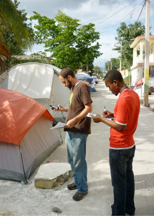
The rich currency and quality of much OSM data suggest the project will become increasingly popular in future decision-making. Studies of data quality already report that OSM out-performs proprietary web served data sets, and rivals many official products (see for example Haklay, 2010). The update mechanism allows more current data for focused areas to be rapidly included in the database, and shows the potential of the project as a decision making tool for dealing with natural disasters and humanitarian crises. Participants in OSM have been involved with humanitarian mapping since the early days of the project, and a Humanitarian OpenStreetMap Team (HOT) was established in the aftermath of the Haiti earthquake in 2010. The OpenStreetMap community successfully mapped Port-au-Prince in greater detail than any other source within two days of the disaster, proving itself crucial for post disaster reconstruction and emergency relief work (Zook et al., 2010) . We can expect many more policy science applications of the project as its data enters the mainstream, and increasing interest in how people deploy OSM-based tools to solve practical real world problems.
Rhythms
Map studies could also focus on the shape of the patterns of mapping in time-space using the notion of rhythm analysis … rhythm analysis can highlight the experience of both mobility and situatedness, and the ways in which they are blended. The rhythms of how mapping appears and disappears in everyday activities could be a productive area to research. (Dodge, Perkins & Kitchin, 2009: 236).
In its default public screens OpenStreetMap displays the most currently available version of the database. However the data in OSM is strongly volatile (Mooney, 2011) – users see a different world every time they log in. To date little research into the rhythms of volatility has been carried out, but a number of profitable research areas stand out. Patterns through which OSM has diffused across the world can be seen in videos from GeoFabrik, Skobbler and ITO World, and charts on the wiki highlight the significant jumps in coverage occasioned by batch imports of data. The overall pattern of a Western European and urban genesis, and subsequent spread, is easy to discern, but work at different scales could usefully explore the particular historical correlates of the changing map. The reasons for rapid take up in Russia but relatively moribund diffusion in the USA need to be explored. The contribution of a mapping party, or a productive individual, or a changed politics could be investigated. The most changed places can be charted (Mooney, 2011). The geographies of deletion could also be explored 6.
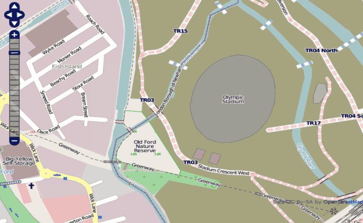
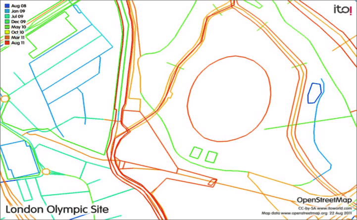
A second focus for rhythm analysis might be much more thematic. Various tools exist for analysing the trends in the use of tags by different users in different places, so the changing thematic geography of the map could also be charted. The general impression is of an early emphasis on main roads in an area, followed by a shift to focus on minor roads, with increased naming of features, and a subsequent thematic enrichment of the data. Once again the processes underpinning these rhythms need exploration. More time sensitive and smaller rhythms in the development of OSM can also be investigated. Spikes in changing coverage of particular features follow the instigation of thematic “projects of the week” for 2010 and 2011 (Weait, 2011). Variations in the time of the day that the database has been updated can also be charted automatically. Other temporal patterns of mapping include rhythms of individual participation and contributions (for example see http://osmbirthday.neis-one.org/). shows some dimensions of the rhythms of OSM mapping of the 2012 Olympic site, with most recent updates for the most dynamic parts of this changing area.
Memories
What we see as a stable map interface on our screens is really provisional instantiation of algorithms and data, fundamentally ephemeral and unstable, made-of-the-moment and disappearing as quickly as electrons are switched and pixels fade. These fleeting map interfaces, that emerge from software spaces, leave new kinds of traces of their presence in the world, a pattern memory of their creation preserved in automatically generated logs of the executing code. (Dodge, Perkins & Kitchin, 2009: 237).
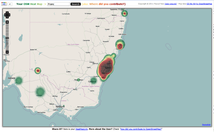
Memories of skill acquisition are mapped out in the help logs on OSM as individuals move through the project. Diaries chart developing mapping experiences, and email trails speak of emerging friendships and at times rivalry. Together these mutable forms highlight individual narratives of an ongoing mapping process (see Pearce, 2008), but visual memories of mapping moments can also be recalled. Historical objects live on hidden in the database – older badly mapped memories can be called back into being by revoking a changeset. And mappers leave traces of their lives in OSM: their journeys with GPS across the globe remain as part of the collaborative map. Tools exist for unpacking these digital memories, to highlight where they have mapped at different scales (see http://wdye.osm-tools.org/ for a simple global map of where you have edited and http://yosmhm.neis-one.org/# which generates heat maps of different participation. Using OSMmapper (http://www.itoworld.com/product/osm/) one can identify more detailed tracings by mappers or date. Tabulated versions of contributions also exist at http://hdyc.neis-one.org/?osmapab. The memories are there to be relived.
Mapping ourselves: creative possibilities
Map studies could explore how academics, including geographers, deploy maps in their everyday praxis, in university laboratories, their offices and lecture halls … the creative possibilities of all this new mapping ought to inform our studies too, and that we ought not to separate the analytical from the creative. People studying maps in creative ways need to be more creative in their mapping activities (Dodge, Perkins & Kitchin, 2009: 238-9).
Over the last seven years a considerable amount of research has been carried out into the nature of OpenStreetMap, but hardly any of this has focused on our role as academics participating in the project. A Google Scholar search for OpenStreetMap on August 20th revealed 2120 items and the web site itself details around 150 different mapping research projects. The vast majority of this research is concerned with advancing the technical capability of the system. Haklay (2011) suggested a code of engagement for academics involved with OSM: academics should map if they want to research the community; read the site and explore the data; put outputs in open access repositories; act as critical fiends for the OSM community and pass results to others by teaching. A limited amount of work is coming to focus on social practices through which OSM operates, which makes a virtue of the positionality of the academic as researcher (see Eckert, 2010; Lin, 2011; Gerlach, 2010; and Perkins, forthcoming) and several PhDs about OSM are nearing completion, so we can expect a growing academic focus on the project in the next few years. But it must be acknowledged that to date academics have contributed little through their formal praxis towards critical understanding of OSM, and that the major creative advances in the project have come from the parts of the OSM community perhaps least involved with academic work.
Conclusions
In 2010, Gerlach suggested that should attend more to complex local assemblages and performances, through which OSM is deployed, and which facilitate new affordances, feelings and ethics. Approaching OpenStreetMap as if it simply deploys technology to represent the world in a new way denies the complex negotiations in everyday mapping practices that embody the project. Seeing its outcomes as somehow a fixed response to a changed political economy also elides the complexity of relations. The project calls forth a new form of expert knowledge in which new skills and motivations are privileged over older certainties, but these forms are themselves strongly contingent and contested. Politics plays out differently as location and discourse changes. Geography matters in OSM, and whilst its emerging form and practices conform in many ways to the cultures of produsage charted by Bruns (2008), the distributed user community, the disparities of coverage and the tensions between ‘do-ocracy’ and regulation reflect a unique configuration.
Our mapping manifesto allows these tensions to be charted and offers a useful framework for considering emergent mapping. It highlights the particular power of code and interface in scripting peoples’ participation and mapping practice. It focuses attention on the continuing significance of aesthetic issues in mapping. It also reveals what has changed, but equally what remains unchanged in authorship. Infrastructure matters for neogeography and tensions over structures continue to be played out in OSM. Methods also impact strongly on this novel mapping project. A consideration of the materiality of embodied mapping practice impacts strongly on product and process and a political economy of the project demands a continuing attention. Ethnographic approaches concerned with affect are needed to unpack the significance of action, feelings and social power in the project.
We also highlight particular moments in the OSM project. Studying failures and points of change in the mapping problematises the often progressive rhetoric of OSM. Focusing on the time-space rhythms of map performance, and the memories of mapping highlights the emergent nature of the project. But focusing upon academic praxis and creative engagement with OSM suggests we should be careful in making strident claims for novelty and difference. Only by recognizing the cultural contingency and local construction of places by a multitude of everyday mappers can one begin to understand the newly emerging ethics of OpenStreetMap. We need to attend in more detail to the modes of crowdsourced mapping, using imaginative methods to unpack the significance of different moments in the at once immutable but also mutable mapping process.
Notes
1. Until May 2010 the project operated under until May 2010 a Creative Commons Attribution-ShareAlike 2.0 license, and since then a process has been instigated for shifting to an Open Database license.
2. See Perkins (forthcoming) for a fuller consideration of relations between the open do-ocratic ethos of the site, the technology-intensive work, and the strongly placed negotiations by groups of participants in different social or virtual contexts.
3. These include: the view that there is a completable and verifiably objective map to be captured; do not copy from proprietary data; don't overwrite unless it is wrong or you know better; participate in the online community; and map the areas you know etc. (see Perkins forthcoming).
4. The Secret Diary of SteveC has poked fun at Steve Coast since December 2007 (see http://fakestevec.blogspot.com/).
5. Mapping Parties are a format invented to encourage a mapping focus on a particular area or theme, increase participation, and develop local mapping communities.
6. Mapping carried out by registered users who are unwilling to sign up for the new licence is to be removed.
References
Beer, D. & Burrows, R. (2007). Sociology and, of and in Web 2.0: Some Initial Considerations. Sociological Research Online 12 (5), http://www.socresonline.org.uk/12/5/17.html.
Brown, B., & Laurier, E. (2005). Maps and journeys: an ethno-methodological investigation. Cartographica The International Journal for Geographic Information and Geovisualization, 40(3), 17-33.
Bruns, A. (2008). Blogs, Wikipedia, Second Life and beyond: from production to produsage. New York: Peter Lang.
Carr, N. G. (2007). The ignorance of crowds. Strategy + Business Magazine 47, 1-5.
Chilton, S. (2011). OpenStreetMap: just a database or catalyst for cartographic revolution. In Schmidt, M. and Gartner, G. (eds.), Proceedings of the 1st European State of the Map Conference, Vienna, July 15-17, 2011, 3-13.
Crampton, J.W. (2003). The political mapping of cyberspace. Edinburgh: Edinburgh University Press.
Crampton, J. W., & Krygier, J. (2006). An introduction to critical cartography. Cartography, 4(1), 11-33.
De Certeau, M. (1984). The practice of everyday life. Berkeley, CA: University of California Press.
Del Casino V., & Hanna, S. (2005). Beyond the “ binaries ”: a methodological intervention for interrogating maps as representational practices. ACME, 4(1) 34-56.
Dodge, M., Kitchin, R. & Perkins, C. (2009). Rethinking maps: new frontiers in cartographic theory. Routledge: London.
Dodge, M., Perkins, C. & Kitchin, R. (2009). Mapping modes, methods and moments: manifesto for map studies. In Dodge, M., Kitchin, R. & Perkins, C. (eds.), Rethinking maps: new frontiers in cartographic theory. Routledge: London, pp. 220-243.
Eckert, J. (2010). Tropes 2.0: mobilization in OpenStreet-Map. Unpublished Masters thesis, University of Washington, Seattle.
Edney, M. (1993). Cartography without “progress”: reinterpreting the nature and historical development of mapmaking. Cartographica, 30(2/3), 54–68.
Gerlach J. (2010). Guest editorial: vernacular mapping and the ethics of what comes next. Cartographica, 45(3), 165-168.
Goodchild, M.F. (2007). Citizens as sensors: the world of volunteered geography. GeoJournal, 69(4), 211–221.
Haklay M. (2010). How good is volunteered geographical information? a comparative study of OpenStreetMap and Ordnance Survey datasets. Environment and Planning B, 37, 682-703.
Haklay M. (2011). Observing from afar or joining the action: OSM and GIScience research. Blog post at http://povesham.wordpress.com/2011/07/16/observing-from-afar-or-joining-the-action-osm-and-giscience-research/.
Haklay M., & Budhathoki, N. (2010). OpenStreetMap: overview and motivational factors. Paper presented to the Horizon Infrastructure Challenge Theme Day, University of Nottingham, March 19, 2010.
Harley J.B. (1989). Deconstructing the map. Cartographica. 26, 1-20.
Kitchin, R., Perkins, C. & Dodge, M. (2009). Introduction. In Dodge, M., Kitchin, R. & Perkins, C. (eds.), Rethinking maps: new frontiers in cartographic theory, Routledge: London, pp. 1-25.
Kitchin R., & Dodge, M. (2007). Rethinking maps. Progress in Human Geography, 31(3), 331-344.
Lammes, S. (2011). Transmitting location: digital cartographical interfaces as transformative material practices. Aether, Journal of Media Geography 11
Latour B. (1990). Visualization and cognition: drawing things together. In Lynch, M. & Woolgar, S. (eds.), Representation in scientific activity. Cambridge Mass.: MIT Press, pp.19-68.
Latour B. (1997). There is no information, only transformation. Interview with Bruno Latour. August 16, 1997, http://www.nettime.org/Lists‐Archives/nettime‐l‐9709/msg00006.html.
Leszczynski, A. (2011). Situating the geoweb in political economy. Progress in Human Geography, 1-18.
Lin, Y.-W. (2011). A qualitative enquiry into OpenStreetMap making. New Review Of Hypermedia And Multimedia. 17(1), 53-71.
MacEachren, A. (1995). How maps work. New York: Guilford Press.
Mooney, P., (2011). Volatile Volunteered Geographic Information (VVGI) - The OpenStreetMap example. Paper presented to the State of the Map Europe Conference, 15th-17th July, Vienna.
O’Reilly T. (2005). What is Web 2.0. The O’Reilly Network. http://www.oreillynet.com/pub/a/ oreilly/tim/news/2005/09/30/what-is-web-20.html.
Pearce, M.W. (2008). Framing the days: Place and narrative in cartography. Cartography and Geographic Information Science, 35(1), 17–32.
Perkins, C. (2008). Cultures of map use. The Cartographic Journal, 45(2), 150-158.
Perkins, C. (forthcoming). Plotting practices and politics: mutable narratives in OpenStreetMap. Transactions of the Institute of British Geographers.
Perkins C. & Dodge, M. (2008). The potential of user-generated cartography: a case study of the OpenStreetMap project and Mapchester Mapping Party. NorthWest Geography 8, 19-32.
Pickles J (2004). A history of spaces: cartographic reason, mapping and the geo-coded world. London: Routledge.
Ramm, F. and Topf, J. (2010). OSM: using and enhancing the free map of the world. Cambridge: UIT Cambridge.
Ritzer, G., & Jurgenson, N. (2010). Production, consumption, prosumption. Journal of Consumer Culture, 10(1), 13.
Silver, D. (2008). History, hype, and hope: an afterward. First Monday, 13(3), http://www.uic.edu/htbin/cgiwrap/bin/ojs/index.php/fm/article/view/2143/1950.
Sui, D. (2008). The ‘wikification’ of GIS and its consequences: or Angelina Jolie’s new tattoo and the future of GIS. Computers, Environment and Urban Systems, 32, 1–5.
Tapscott D., & Williams, A.D. (2006). Wikinomics. how mass collaboration changes everything New York: Penguin.
Turner, A. (2006). Introduction to neogeography. Sebastopol, CA: O’Reilly Media.
Van Exel, M. and Dias, E. (2011). Towards a methodology for trust stratification in VGI, http://vgi.spatial.ucsb.edu/sites/vgi.spatial.ucsb.edu/files/file/aag/van_Exel_abstract.pdf.
Weber, P. and Jones, C. E. (2011). Usability of editors: what to improve In Schmidt, M. and Gartner, G. (eds.), Proceedings of the 1st European State of the Map Conference, Vienna, July 15-17, 2011, 14-33.
Weaitt, R. (2011). Advocacy in small ways: Project of the Week, http://sotm-eu.org/slides/71_RichardWeait_potw_numbers.pdf.
Wood, D. (1992). The power of maps. New York Guilford Press.
Wood, D. (2008). The natures of maps. Chicago: University of Chicago Press.
Wood, D. (2009). Rethinking the power of maps. New York: Guilford Press.
Zimmer, M. (2008). Critical Perspectives on Web 2.0. First Monday, 13(3), http://firstmonday.org/htbin/cgiwrap/bin/ojs/index.php/fm/article/view/2137/1943
Zook. M.A., Graham, M., Shelton, T. & Gorman, S. (2010). Volunteered Geographic Information and crowdsourcing disaster relief: a case study of the Haitian earthquake. World Medical & Health Policy 2(2), http://www.psocommons.org/wmhp/vol2/iss2/art2/.
About the author
Chris Perkins is Senior Lecturer in Geography in the School of Environment and Development University of Manchester and first Chair of the International Cartographic Association Research Commission on Maps and Society. In Manchester he currently teaches classes relating to Envisioning Spaces, Maps in Society and Islands. He is the author and editor of eight books including Rethinking Maps (Routledge 2009) and The Map Reader (Wiley, 2011) and author of around 100 academic articles. Current projects include a critical mapping history of Manchester, work around the possibilities of a more playful imagining of mapping, and explorations of mutable meanings and relationships between mapping and social contexts and tasks.