 Ecologies of place: emergent mapping practices, research perspectives and scenarios
Abstract
Digital technologies are increasingly providing a range of emerging possibilities for social enablement, and for engagement with local cultures and practices. The potential and actual functionality of Google Maps, Google Earth and other combinations of internet data immersion events, systems and projects (‘mashups’) raise questions around the quality and function of such emerging forms of embodied and virtual knowledge practices for urban cultural contexts. The strategic significance of how emergent mapping practices can engage with, and discover, new knowledge about urban configurations needs critical consideration.
This article provides a critical overview of how some of these issues are explored at a trans-disciplinary workshop titled “Ecologies of Place”. This definition is given as a means through which to engage with both human and non-human forms of agency and materiality. Using a variety of mapping approaches across a range of disciplines, the intention was to challenge existing assumptions, engage with multiple discourses and open up new areas for potential research. This essay describes and critiques some of these emergent mapping approaches and describes in greater detail one mapping approach titled Future Research Scenario (FRS) through two case studies. This emergent mapping approach is located within the broader field of futurist practices around scenario thinking, and the defining of research questions. The FRS mapping approach involves participatory de-construction of planning proposals around what is termed the “Ecology of Place”. These representations are discussed as highly contextual, and driven by the involvement of the participants as relational problem explorations around defining questions for further research. Each case study leads to different outcomes highlighting strengths and difficulties that are contrasted as unique configurations of local mapping practices.
Mapping as relational problem solving
Maps are spatial representations of the world that involve construction of social knowledge across a wide range of disciplines. As graphic displays, they can be understood as extensions of the human body (Cosgrove, 1999), rendering the unseen through spatial patterns. Audiences and readers invest maps with power and authority that are not always understood. This is largely driven through the authority given over to cartographic conventions as renderings of spatial hegemony (Sparke, 1998). Corner (1999) argues for a more optimistic and emancipatory understanding of mapping as a form of relational reasoning, where new realities may be construed out of existing limits and boundaries. Corner refers to Deleuze and Guattari’s (1987) evocation of mapping as a performative practice, describing four key processes for dynamic and tactical mapping practices as “drift”, “layering”, “game-board”, and “rhizome”. He comments on the potential for these and other techniques to reveal new potentials:
What remains unseen and unrealized across seemingly exhausted grounds becomes actualized anew with the liberating efficacy of creatively aligned cartographic procedures. Mapping may thus retain its original entrepreneurial and exploratory character, actualizing within its virtual spaces new territories and prospects out of pervasive yet dormant conditions (Corner, in Cosgrove, 1999: 251)
Corner’s call to optimistic and creative uses of mapping has been taken up by creative artists and media practitioners through their usage of geospatial technologies to work with affective and poetic contexts. Nold’s (2005) work on emotional cartography engages communities by recording affective and emotive data that is spatially located. This participatory mapping approach has the potential to reinvigorate communities through representations of complex interactions and relationships across both human and non-human factors.
Thinking of maps as mutable yet fixed in their specificity understanding challenges assumptions about mapping as a neutral recording of spatial cartographic data, instead of as an ambiguous, hybrid, mutable and polyphonous set of practices. Emergent mapping practices are thus understood as forms of knowledge practice that can question and challenge existing territories and knowledge boundaries, through mapping practices understood as forms of relational problem solving. As Kitchin and Dodge point out:
Maps are ontogenetic in nature. Maps are of-the-moment, brought into being through practices (embodied, social, technical), always re-made every time they are engaged with; mapping is a process of constant re-territorialisation. As such, maps are transitory and fleeting, being contingent, relational and context-dependent. Maps are practices – they are always mapping; spatial practices enacted to solve relational problems (Kitchin and Dodge, 2011:109).
Seen in this way, emergent mapping practices can be understood as a process of constant reframing of territories as representations and interpretations of a variety of data sets composed as relational problems. However, such a broad positioning of emergent mapping also introduces a range of complexities for researchers that are beyond the scope of this paper. For example, there are questions about the processes and practices of integrative research involving collaborations of expertise between academic and non-academic actors.
This complex dynamic suggests a need for greater clarity around what is understood by terms such as ‘multidisciplinary’ and ‘participatory’ research. Tress, Tress and Fry (2006) propose a way to interpret integrative research processes through what they call a “knowledge cycle”. Similarly, the proliferation of participatory mapping (PM) involving a wide range of stakeholders has prompted questions about the process of facilitation, and ethical considerations about map ownership and empowerment. Chambers highlights the agency of the PM facilitator in an era of what he terms “new plurality eclecticism and creativity in PMs” (Chambers, 2006:1).
Dialectic between scientific mapping and cultural mapping
The changes in digital technologies have opened up new approaches for geographic and spatial mapping that has significant functional and social consequences for geographic research. Haklay, Singleton and Parker (2008) provide a critical overview of the impact of Web 2.0 mapping and “neogeography” and highlight the new potentials of open collaborative systems to address both local and global challenges. They note these developments as opportunities for the field of geography research to be reinvigorated around social and global concerns through the inter-operability of empirical and qualitative data. They also comment on the complexities of maintaining quality and validity of crowd-sourced data and the need for further consideration of these tensions for research practice.
What is at stake in these new forms of digital mapping is a renegotiation of the dialectic between the objectivity of rational scientific spatial data and the place of interpretative qualitative data as cultural and social knowledges. Whilst scientific modeling systems using geo and spatial digital data can reveal patterns of activity and interrelationships across and through data layers, the tensions created by the coming together of such scientific geo-spatial modeling with more speculative cultural interpretations are a significant dialectic in emergent mapping practices. These tensions are encoded within, and through, the authority of the map itself as knowledge outcome that challenges existing orders of cartographic authority and suggests a move away from predictable critical analyses based on hermeneutics toward a wider, and more inventive, mode of documenting that also encompasses the role and workings of sensory affects.
As such, mapping can be conceptualized as a research practice about constructing emergent assemblages for connecting, interpreting and observing patterns of movement, force and affect across very diverse formal and disciplinary divides. As Ulmer (1988) comments, the organisation of research is increasingly about the management, storage and orientation of information as potential and emerging assemblages:
The goals of organizing research are no longer primarily concerned with descriptive ends (i.e., not merely ‘trac-ing’ information). From a ‘point system’ of memory based on predictability, media studies shift to a ‘block-system’ of ‘anti-memory’ based on becoming. Speed, movement, and rhythm rather than place or horizon become crucial to a way of storing, retrieving, and linking information, which maps potential assemblages rather than merely tracing facts – a pragmatics (Ulmer, 1988: 440).
The significance of the visual in mapping practices
Elwood (2010) highlights the need for more critical approaches to visual methods in the field of information science. She discusses the particular role of the ‘visual’ as a significant conceptual aspect of much of spatial and digital research, and comments on the importance of continuing to develop these emergent practices for multidisciplinary research:
The geoweb has emerged in parallel with exciting new work on visualisation, visual ontologies, social sciences, and arts and humanities. In our efforts to understand what is at stake in the geoweb, for geography and for society more broadly, we must continue utilizing these new conceptual resources in creative and integrative ways. (Elwood, 2010:406)
Whilst Elwood stresses the significance of the visual within research and knowledge studies, Elkins (2003) proposes the development of a general field of visual studies that encompasses a wide range of discipline fields. Similarly, Stafford argues that the “visualization of knowledge” is integral to the effective functioning of all disciplines and academic teaching programs:
The history of the general move toward visualization thus has broad intellectual and practical implications for the conduct of and the theory of the humanities, the physical and biological sciences, and the social sciences – indeed, for all forms of education, top to bottom (Stafford, 1996: 23)
As Elkins (2003) suggests however, moves towards building such a specialized field of “visual studies” in its own entity is potentially problematic. The difficulty as he suggests, is a possible silo effect of disengagement, limiting opportunities for cross-fertilisation provided in combined and multiple critical approaches to the visual as a theoretical and conceptual field of study. Perhaps the field of emergent mapping practices offers one way in which to transcend such a problematic, by engaging across disciplinary fields whilst maintaining discipline specificity. To this end, the workshop on emergent mapping practices took place around a thematic link of “Ecologies of Place” as a space for exploration and inter-disciplinary exchange that involve both human and non-human forms and features of agency. The specific intention and definition of how this term was being used for the workshop was critical in establishing a common focus for a variety of approaches resulting in fruitful and engaging set of presentations.
The workshop definition for the term “Ecology of Place” is informed by a theoretical framing of the workings of both human and non-human forms of agency, drawing largely on Bennett’s (2010) notion of “vibrant matter,” and in turn her reading of Latour’s (2004) descriptions of multiple modes of distributed agency. For our purposes, we provide the following description as a framework for the mapping workshop. Our description was useful as a framework for the workshop call for papers:
Ecology of Place – understood to involve the interconnected movement of materials, energy forms, objects and agents within living communities. The range of potential forms of ecological interconnection that might be mapped includes the biodiversity found in nature, information system flows, and elements of cultural and social fabric that are part of living communities as interconnected environments.
Emerging critical frameworks
Mapping, configured as an emergent practice with the potential to engage scientific epistemologies within more speculative knowledge practices, was critiqued within a transdisciplinary field. Key critical approaches included mapping practices and their value as collaborative practices and participatory tools; the ontological underpinning of mapping practices to inform new perspectives of the ‘map’ as a material and affective object; and emergent mapping practices with the potential to reveal new research problems and questions, as well as being instrumental for facilitating new directions in policy and planning contexts.
Key themes from the range of papers presented are summarised below. Many of these themes highlight the collision of epistemologies that results from mapping where quantitative rationality of scientific spatial data is assembled with qualitative socio-cultural data. In this way, the workshop findings support the value of mapping practices for developing new research directions and approaches.
Emerging workshop themes
Mapping as cartographic (participatory) digital practice
The critique of Open Street Map (OSM) challenges the myth of fixity in maps through critically reviewing the wide reaching democratizing potential for individuals and groups to enter local geo content. The OSM software exists as a potential archive of micro details about usage and entry patterns that could be further explored through research. Crowd-sourced geographic space mapping is pragmatic, mutable and not always entirely open to all, as content provisioning is often done by informal elites. New approaches are needed to research the cultural contingency and local construction of place through crowd sourced mapping practices.
Mapping as embedded application within a real time digital interface
The availability of Google Maps in smart phone and mobile digital devices was critiqued as a form of utopian narrative about the digital, real time enhancement of everyday living. In this way, digital mapping applications (geo-tagging, Four square, Google Maps) need to be more critically understood as conceptual framings of urban spatiality within real time contexts. Engagement by users of mapping applications are thus considered as a pervasive state of situated-ness with relationship to the urban environment – as a moment of repeated and habitual encounter between multiple forces (users, devices, spaces) and landscapes (physical, Hertzian, virtual).
Mapping as a performative event linked to an affective network
The establishment of a live participatory mapping event was discussed as a means through which the materiality of the data itself might be revealed; that is, the act of real time mapping provides an occasion to engage with raw sensory data where what is mapped as a representation of real-time can facilitate further real-time interactions at the event. The mapping process then becomes a performative action that is a means to access complex data flows and structures within a much wider network of power and affective relations.
Mapping of conceptual frameworks linking the spatial, temporal and historical
A critique of Modernist thinking highlights the technologies of representation as implicitly and explicitly prioritising particular temporal/spatial relations. The exploration of these relationships are diversely captured by maps and mapping. Thus technologies of mapping have played a pivotal role in the emergence of a form of temporal experience that has been central to modernity, and still holds sway within contemporary globalised western culture – the temporality of the ‘fresh’ and of the continuous present. Conversely, maps can also be repositories of memory and sites of narrative, both invoking very different temporalities from that of the ‘fresh’. These diverse temporalities, variously invoked by maps and the technologies of mapping, are constitutive of different orientations to the world and to made things, and have very different implications for a range of urban issues.
Mapping as organising process of translation
The map can be seen as an ontologic object, subject to constant change. Mapping makes it possible to reveal or make visible what may be difficult to explain. Mapping is thus useful for revealing new patterns, for example, of labour and mobility that are found as traces within existing visual media and that can be recombined or re-interpreted as maps of networked activity – in this sense the visual is not representational but organisational. Implicit within this are methods and processes of translation that speak to conflicting interests, subjectivities and technics of communication.
Mapping as a practice of designing
Currently, a significant question is how to shift from movements to trajectories – that is from strict goal-orientedness to shared vectors, from fixed locations to mobility, from processes rather than places. A new, hybrid practice is emerging where the distinction between map, diagram, plan, visualisation start to blur. Mapping can defer designing. It can be a strategy for intervening in a design process, complicating and deferring the finalised design by calling attention to what has not been mapped. In culturally specific ways, mapping practices and the relationship between maps and other media of local knowledge operate as mnemonics for or projections of each other. Mapping thus can by useful as to reveal tacit and embedded social practices that reflect cultural and social creativity.
Mapping as creative practice
Creative mapping of traces and elements of visual, aural and sensorial data that are not spatial, but affective and emotional aspects of material cultures can reveal other ways of experiencing place. Such mappings can enunciate spatial concepts by utilising cartographic principles and applying them in ways that challenge the existing epistemologies of defined and bounded spatial territories. Creative works that explore and experiment with data ecologies and visualisations engage with a poetics of digital media design. They also call into question through rhetorical evocations and depictions the relationships between nature/culture and urban contexts. These mappings speak to the analogic and metaphoric nature of the visual field.
Future studies, scenario practice models and FRS mapping – defining research questions
Developing scenarios is an established model within the field of future studies, involving a wide range of techniques and approaches for predicting and proposing future trends and possibilities. Whilst it is not possible to fully describe the depth of the field in this paper, elements from the field do inform a particular approach that is described here as “Future Research Scenario (FRS) Mapping”. In this approach, the point of departure is an existing planning report – a scenario that has already been developed and is then de-constructed using FRS mapping methods. FRS uses mapping techniques that work as forms of relational layering and rhizomatic linking of relevant and disparate knowledge and details that aim to propose future research questions. Whilst there are many models and definitions for scenario work, there are two models that help contextualize our FRS approach. Firstly, Bishop, Hines and Collins provide a definition of scenario types:
Suffice to say that a scenario is a product that describes some possible future state and/or that tells the story about how such a state might come about. The former are referred to as end state or even day in the life scenarios; the latter are chain (of events) scenarios or future histories (Bishop, Hines & Collins, 2007: 8).
FRS mapping fits somewhat within the above description of a scenario type as “chain scenarios or future histories”, as it seeks to unpick an already constructed scenario projection to reveal within it new possibilities for further research through use of mapping techniques.
Secondly, Sarpong and Maclean provide useful conceptual understanding of scenario development as an “everyday social practice played out in the day-to-day activities of a group of competent actors as an actualization of a continuous process of becoming” (2011: 1154).
Their emphasis on the process of scenario development as a collaborative form of social practice engages notions of past, present and future in a form of relational thinking that is mutable and flexible. They describe the three elements of their model:
So, in conceptualizing scenario thinking as a social practice, we give ontological priority to organizational members and those regular discernable patterns of activities that take place within the ambit of their praxis. Epistemological primacy is placed on the actors’ quest to understand the future of their complex business environment, which is characterized by uncertainty, serving to condition the actors’ behavior and conduct in their everyday situated practice (praxeology) (Sarpong & Maclean, 2011:1156)
shows Sarpong and Maclean’s practice approach to scenario thinking that is similar to the approach taken for the FRS mapping activity, shown in . The key difference between FRS and their model is in the objectives and outcomes – where their model seeks to provide a framework for industry teams seeking innovation outcomes, the FRS approach seeks to provide potential research directions around existing projects. As shown in , the FRS mapping approach draws out the stage of epistemological inquiry as part of the scenario thinking, by the mapping of human and non-human agencies of past, present and future.
Ontology |
Epistemology |
Praxeology |
|
System |
Flow Dynamics |
Narrative/Agency |
Outcomes |
The Ecology of Place: Identify representational and non-representational elements |
Narratives in public discourse |
Identify conflicts |
How can mapping help reveal these? Could the process of mapping further inform new perspectives for future research? |
Critical frameworks |
Identify stakeholders |
||
Underlying assumptions |
Identify forms of agency |
||
As a form of mapping, the FRS approach thus uses mapping to convey epistemological aspects as representational narrative themes in public discourse, and further, as conflicts, stakeholders and forms of agency that include human and non-human elements. As Del Casino and Hanna comment, representations are constantly mediated by and through actors and practices in a process of ‘becoming’:
Yet maps to borrow from Gibson (2001) are in a state of “becoming”. As such, maps stretch beyond their physical boundaries; they are not limited by the paper on which they are printed or the wall upon which they may be scrawled. Each crease, fold and tear produces a new rendering, a new possibility, a new (re)presentation, a new moment of production and consumption, authoring and reading, objectification and subjectification, representation and practice (Del Casino and Hanna 2006: 36).
The practice of FRS mapping is described below as one approach amongst many that seek to challenge existing epistemological frameworks, by suggesting new critical perspectives and identifying complex values and relationships that work at the local level. The findings from each of the studies suggest potential directions for new research for each case context, in the form of questions for further consideration.
FRS case studies
The two FRS case examples, Barangaroo Urban Redevelopment and Sydney City Farm, are local Sydney places that have been the subject of ongoing public debate – consultation and subsequent planning design proposals. Whilst the same approach was taken in both case-mapping activities, the actual maps produced very different findings based on the nature of each urban proposal being critiqued as well as the idiosyncratic and communal workings and inputs of the participants. This result highlights the performative pragmatic nature of mapping as a form of participatory collaborative scenario thinking – as a state of ‘becoming’.
Study 1: Barangaroo
Background as industrial site development
Redevelopment of former industrial sites exemplifies the agency of Late Capitalism in the form of multinational corporations, globalised markets and mass consumption, particularly evident in the redevelopment of docklands. London Docklands in the mid 1980s was a flagship for urban development on former port sites. Facilitated by the London Docklands Development Corporation, developments were unhindered by planning considerations. This became the model for many similar dockland redevelopments, free of many planning constraints, including no public participation and encouraged by the Enterprise Zones which removed certain tax burdens and encouraged ‘fast-tracking,’ London Docklands was entirely a market-driven project (Collins, 2009).
In 2011, this model continues to underpin proposals for former docks globally. In Sydney, debates rage around the proposed redevelopment of a former dock adjoining the CBD. Known as Barangaroo, the development is highly controversial. Known as Millers Point West, Barangaroo is a 22-hectare land parcel, located along the western edge of Millers Point, adjacent to the Sydney CBD. Formerly an open cove of Sydney Harbour with projecting finger wharves, it was filled in the 1970s and has been subsequently used to unload shipping containers. This operation has recently been relocated and the site vacated. The NSW Government resolved to create a new western edge to the CBD city area, as well as new foreshore park at the north of the site. The Barangaroo Development Authority describes the complex in glowing utopians terms:
What is Barangaroo?
Barangaroo is a vacant 22 hectare former container wharf on the western harbour foreshore of the Sydney CBD. Over the next decade it is being transformed into a thriving public, residential and commercial precinct with a waterfront promenade running the length of the site. Incorporating a major new Headland Park, it is one of the most ambitious and significant waterfront redevelopments anywhere in the world (http://www.barangaroo.com/discover-barangaroo/faqs.aspx).
Issues and constraints of stakeholder conflict - the existing design proposal
The State Government requires the development be “cost neutral”, with an added expectation that a large foreshore park be established by the developers who would then be compensated by a significant increase in the height and bulk of the proposed commercial towers. The public expressed alarm at what appeared to be an increasing over-development of the site, but also at the lack of transparency of the approval process. A “Barangaroo Action Group” thus demanded open planning processes and that commercial consideration not outweigh environmental factors. Escalating public protests resulted in some modification of the scale with the developer slightly reducing the mass of the first three giant office towers. In all the debates, the focus has been on issues concerning scale, parkland access, CBD commercial activities and tourism, and the viability of a landmark high-rise hotel hovering over the harbour. The National Trust has also argued for the value of Sydney Harbour continuing as a “working harbour” in the form of a cruise ship terminal located on the site.
Barangaroo mapping as a process of ‘becoming’ towards future research objectives
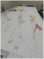
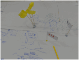
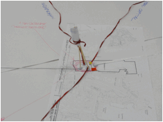
The Barangaroo scenario-mapping project began by linking past, present and future through the definition of the “Ecology of Place” to understand the cultural flows and contemporary tensions in the site, understood in as the ‘ontology’. Coloured flags were used to mark significant events and white flags with text marked underlying ideologies driving the events shown in .
 |
 |
 |
| 1B | 1C | |
| Figure 3: Maps 1A, 1B, 1C | ||
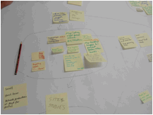
The second stage ( – epistemology) involves the two linked mappings of Key Narratives and Critical Frameworks. It was here that the complex nature of the contested narratives about proposals for the site and the position of key interest groups became more visible.
Key Narratives in Public Discourse |
Critical Frameworks for Narratives |
Historical 19th Century Windmills Gas Lighting gasworks Sail to steamships and wharves 20th Century Plague! The Cut Long finger wharves and bond Stores Headland replaced by concrete apron 21st Century Container ships to Port Botany Sydney Global centre for Asia Pacific |
Historical Narrative Concept of heritage – the history wars Concept of precedent Anthropological Studies Colonial and Post-colonial studies |
Social The Cadigal People The Convict settlers Working Class District Gender flows Labor Relations Gentrification Governance |
Social Narrative Exploitation and Appropriation Epidemiology Industrial Relations Community Conflict Studies |
Cultural Indigenous Culture 18th century landscape aesthetics; the Sublime, the Beautiful and the Picturesque 19th Century Commodity Culture Colonialism Nationalism Multiculturalism Neo-liberalism City Identity and Image |
Cultural Narrative Indigenous cultural studies Gender Politics The Aesthetics of place The Economics of Commodities The politics of city image and identity Neo-liberalism vs. Socialism Community and Governance |
|
Environmental The site as water The site as quarry – sandstone Extensive use of turpentine timber The site within prevailing winds Aquatic and terrestrial wildlife Pollution of marine environment Toxicity of land-filled areas due to industrial use |
Environmental Narrative 18th century Antipodean Studies Australian environmental history; timber-getting, gold, wool, coal Regional environmental studies Environmental protection legislation |
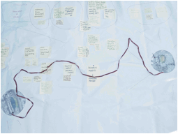
Mapping the question, “Where are the conflicts and who are the stakeholders involved?” showed how key conflicts over flows of money and investment, power and concepts of progress were endemic in the perceptions in the wider community about large urban development projects. The critical frameworks that informed the social and cultural narratives, revealed through the mapping, flagged the potential for research into such a “culture of suspicion” associated with urban redevelopment in Sydney specifically and in the state of New South Wales more generally.
Conflicts over “Aesthetics of Place” were seen to be closely linked to specific stakeholders and issues of power. For example, the Barangaroo Planning Authority has the power to override local government who had raised issues over the scale of buildings and their ability to block views and sunlight in a significant public space identified in .
Conflicts over “Forms of Representation – the Bird’s Eye View” raised the issue of why the high-rise tower with unrestricted views is both the model with the most monetary value and yet is the most contested form in the wider community. This pointed to potential research on the meaning of the Sublime in a commodified urban context, identified in .
 |
 |
Barangaroo is such a highly charged site within a global context that local mapping seemed inadequate. Instead, it was felt that there were two major research areas that could be pursued:
- Exploring the Hermeneutics of Suspicion that relates to large planning projects. Can Mapping engage with the public distrust about planning processes?
- Exploring the role of the visual in calling something into being. Can Mapping help explore the role of the visual as a construct of the ‘Sublime’ in locating proposed developments?
Study 2: Sydney City Farm
Background context
In contrast to the conflicted status of the Barangaroo proposal, the Clouston SCF design proposal engaged with a lengthy and consultative community consultation. The final design involves the development of a set of institutional and community partnerships, working across what is termed an “articulated model” for the development of a city farm across two linked spaces on the edges of the Sydney CBD. These are the Powerhouse Museum car park site and Sydney Park at St Peters. Each space is currently managed by a different local city council authority (City of Sydney and Marrickville local councils). Local authorities and institutions at the edge of the CBD physically bound the museum car park space.
The involvement of the museum in the proposal is potentially significant as it introduces the possibility of educational focus alongside the development of a community approach to urban agriculture. The Sydney Park space was previously an industrial brickworks site and was then reclaimed using landfill into an inner city park. The park is currently one of few green spaces in this highly urbanised inner city area. The consultancy report comprehensively details a wide range of material, social, and conceptual elements relating to the development of what is understood by a “City Farm”. These are well conceived and logically developed as an argument towards the articulated site proposal based on a conceptual framing of the role of the ‘city farm’ as found in other sites:
As city farms are an emerging phenomenon, management structures vary according to individual community requirements, however, for the purposes of this study and based on an overview of a number of city farm models; the key characteristics of a city farm referenced in Clouston’s consultancy report are considered to be:
Productive landscape, working with plants, animals and people;
Educational and network centre;
Integrated within the urban area;
Community based project;
Promotable healthy urban environments and lifestyle;
Financially feasible enterprise (Glover 2003a, Khan 1999, Hunter 2009) http://www.cityofsydney.nsw.gov.au/council/documents/OnExhibition/CityFarmFEASIBILITYSTUDY.PDF (Clouston Report: 14).
As a background document, the Clouston report makes a solid case for the articulated proposal, as well as identifying the need for engagement of local communities and institutional partners to make the plan a reality. Whilst this is clearly stated, there is a focus on specific objectives in the report that do not include the operational synthesis that is outside the given brief. This critical aspect became the starting point for the mapping activity that relate directly to the material and community oriented processes that would need to take place in order to develop the proposal. These suggestions were noted by workshop participants as hand-written references that were arranged and organised as part of the mapping activity. The final outcome () is a cylindrical map that linked a diversity of elements and features that speak to how individuals and communities might be engaged. This final map is as a form of ‘becoming’, as it seeks to represent the myriad of human and non-human agents that make up the complex relational problem existing across and through the two sites to make the Clouston proposal a reality.
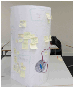
Approaches suggested through the mapping process include links to a wide range of community groups, and other institutions within the local area, to develop information, share activities and educational materials and events around the activities of the SCF, as well as opportunities for events and cultural activities that engage with local histories, objects and artefacts. These elements are indicated within the flow of the map, as sections that flow around the 3-dimensional spaces of the map. In particular, two distinct aspects were featured as key critical frameworks for further research, as described below.
Map 2 highlights the composition of public and private infrastructures and systems between the museum and park. The mapping process identified the positive potential benefits for local councils to re-negotiate shared boundaries, and work towards planning objectives to increase integration of public and green space and to promote these links associated with the SCF project.
Map 3 highlights the extent of future mappings that could be undertaken to link the two spaces by emphasising the micro details of the local cultural economies, bringing spatial, economic, planning and cultural data into play. These include mappings of what grows where; underground spaces; backyard productions and access ways between the two sites; existing urban verge vegetation; existing retail food outlets and patterns of access and consumption; existing and past restaurants and food outlets; and building heights and possible elevated green spaces.
The two research questions that arose from this FRS mapping process are:
- What forms of agency are involved in the process of consultation for the SCF project? How do these engage with institutional stakeholders and local communities and individuals?
- How can the local, material aspects of the urban context (formal and informal production) be mapped to inform new feasible options for the SCF articulated proposal?
The scenario mapping activity for each site study using the FRS mapping technique produced findings that are specific and contextual. Both planning proposals reflect generalising global principles for urban development – in the case of Barangaroo, these are related to the concept of a “world class city” with a showcase development, and for the SCF, the development of a city farm based around existing urban models applied in other global cities. What became clear as a result of the FRS mapping activity is that the performance of the mapping by each group of participants produced very different interpretations of the technique, and as a result, mapping styles and research futures outcomes. In the case of Barangaroo, the future research is linked to conceptual and ideological concerns specific to the political and aesthetic domains of local Sydney development. In contrast, the SCF research futures findings suggest the need to further research through further spatial mapping of human and non-human elements, the missing links of the material and communal territory of the real-time, real-world lived environment.
Conclusion
As suggested by Elkins (2003) and Stafford (1996) among others, the visualisation of knowledges through digital technologies presents a range of new challenges and opportunities. As discussed in this article, the workshop “Ecologies of Place” produced a wide range of emergent approaches to mapping demonstrating the dynamic qualities of the field, as it relates to a variety of disciplinary fields and practices. Ideas about the relationship between place, and space; identifying affective and imaginative boundaries; and ontological ambiguities and tensions are important issues to explore. The role of data visualization, and participatory mapping to engage with, and reveal, new knowledge that informs and engages with a range of disciplines are considered as a critical features of, and opportunities for, emergent mapping practices.
References
Barangaroo Sydney Australia http://www.barangaroo.com/discover-barangaroo/overview.aspx
Bennett, J. (2010). Vibrant Matter A Political Ecology of Things Duke University Press.
Bishop, P., Hines, A. and Collins, T. (2007). The current state of scenario development: an overview of techniques Foresight 9 (1) 5-25
Chambers, R. (2006). Participatory Mapping and Geographic Information Systems: Whose map? Who is empowered and who is disempowered? Who gains and who loses? The Electronic Journal on Information Systems in Developing Countries 25, 2, 1-11 Available from http://www.ejisdc.org
City Farm Feasibility Study Clouston and Associates October 2010 Retrieved from http://www.cityofsydney.nsw.gov.au/council/documents/OnExhibition/CityFarmFEASIBILITYSTUDY.PDF
Collins, M. (2009, 5 August). Legacy of the Docks The Guardian Retrieved from http://www.guardian.co.uk/society/2009/aug/05/london-docklands-legacy-development-regeneration?INTCMP=SRCH
Corner, James (1999) The Agency of Mapping: Speculation, Critique and Invention. In Cosgrove, D. (ed) Mappings London: Reakiton Books London
Cosgrove, D. (1999) (ed) Mappings London: Reakiton Books London
Del Casino, V. & Hanna, S. (2006). Beyond the Binaries: A Methodological Intervention for Interrogating Maps as Representational Practices ACME : An International E-Journal for Critical Geographies 4(1) 34-56
Deleuze, G. & Guattari, F. (1987) A Thousand Plateaus: Capitalism and Schizophrenia. Minneapolis, MN: University of Minnesota Press.
Elkins, J. (2003). Visual Studies: A Skeptical Introduction New York Routledge
Elwood, S. (2010). Information Science: Visualization, visual methods, and the geoweb Progress in Human 35(3) 401-408.
Gibson, K. (2001). Regional subjection and becoming Environment and Planning D: Society and Space 19 (6) 639-667.
Haklay, M., Singleton, A., Parker, C. (2008). Web Mapping 2.0: The Neogeography of the GeoWeb Geography Compass 2(6) 2011-2039.
Kitchin, R. Dodge, M. (2011). Rethinking Maps In M. Dodge, R. Kitchin & C. Perkins (Eds). The Map Reader: Theories of Mapping Practice and Cartographic Representation UK: Wily-Blackwell p.109.
Latour, B. (2004) Politics of Nature: How to Bring the Sciences into Democracy [Trans. Catherine Porter]. Cambridge: Harvard University Press
Nold, C. (2005) Greenwich Emotion Map. Retrieved from http://www.emotionmap.net
Sarpong, D. & Maclean, M. (2011). Scenario thinking: A practice-based approach for the identification of opportunities for innovation Futures 43 (2011) 1154-1163.
Sparke, M. (1998). A Map that Roared and an Original Atlas: Canada, Cartography, and the Narration of a Nation Annals of the Association of American Geographers 88(3) 463-495
Stafford, B. (1996). Good Looking: Essays on the Virtue of Images Cambridge, Mass: MIT Press
Tress, B. Tress, G. & Fry, G. (2006: (13- 27)). Defining concepts and the process of knowledge production in integrative research. In B. Tress, B., G. Tress, G. Fry & P. Opdam (eds). From Landscape research to landscape planning: aspects of integration, education and application Springer, Netherlands.
Ulmer, G. (1988). Handbook for a Theory Hobby Visible Language, 22: 399-422
About the authors
Helen Armstrong is Professor-Emeritus at Queensland University of Technology
Helen was the Inaugural Professor of Landscape Architecture at Queensland University of Technology 1997-2003. She is currently a practicing landscape architect and Adjunct- Professor, Institute for Culture and Society (ICS), UWS. She has undertaken a number of projects in Western Sydney, both research and practice, which have involved various forms of mapping. Her Guide to Creative Mapping with Communities produced in 2008explored creative mapping with a range of diverse communities.
Kaye Shumack, School of Humanities & Communication Arts, University of Western Sydney
Kaye is Associate Professor in design and visual communication in the School of Humanities and Communication Arts at UWS. She is a practicing artist, design theorist and media producer. Current projects include mapping as participatory practices of critical visualisation of local contexts around transport mobility, urban landscapes and food systems.